Forest Plan / Context / Progress So Far

Progress So Far
Context of Cumbria Community Forest
Cumbria Community Forest’s full boundary is 1388 square miles, or 3595 square kilometres. 97% of this land area is classed as ‘rural’ whilst 3% is ‘urban’. Figure 6 shows this overall percentage split within the forest boundary.
Cumbria Community Forest is home to a population of 381,732, averaging 106 people per square kilometre contrasting with an average of 434 people per square kilometre across England [17].
Areas of high-density population are concentrated into post-industrial towns; whilst rural communities span an agricultural landscape in many smaller settlements.
Figure 6: Land classed as 'Urban' or 'Rural' within Cumbria Community Forest’s boundary

The Index of Multiple Deprivation measures relative deprivation at small local area levels across England [18].
It takes Census data on full-time residents in a local area and groups it into ‘Lower-layer Super Output Areas’ (LSOAs).
LSOAs are geographic areas with an average population of 1500 people. They are helpful as a tool for comparison of populations across England, such as relative deprivation.
In the Cumbria Community Forest boundary, 26 LSOAs fall into the 10% most deprived areas of England, as shown in figure 7.
Figure 7: Map showing the 26 LSOA's within the CCF boundary which fall into the most deprived decile of England's population

41% of Cumbria Community Forest’s area overlaps with three different protected landscapes (figure 8):
- Lake District National Park Authority
- Solway Coast National Landscape
- North Pennines National Landscape
Figure 8: Map illustrating where protected landscapes overlap with the Cumbria Community Forest area

There are 221 square kilometres of ‘low sensitivity’ land for woodland creation, or 6% of land within the CCF boundary.
Geospatial analysis was carried out as part of our planning process, to model scenarios based on multiple layers of spatial data which has given a detailed understanding of local opportunities for woodland creation.

Progress of Cumbria Community Forest
When Cumbria Community Forest was launched in 2021, existing tree and woodland cover within the forest boundary was 45,903 hectares, or 12.77% of total land area. In 2023 this area had increased by 854 hectares [M]: an additional 0.24% of tree and woodland cover delivered over two years by all woodland creation partners (including Raise, Forestry Commission, Eden Rivers Trusts, West Cumbria Rivers Trust, Natural England) using a range of funding sources.
To put that into perspective, over a two-year period, new trees and woodlands were established across an area equivalent to approximately 1.6 times the area of the Sellafield site or 1.6 times the area of Bassenthwaite Lake.
Cumbria Community Forest establishes woodland across the landscape which balances a range of aims and benefits. Each woodland created has its own mix of strengths and benefits. For example, some woodland creation sites have high levels of community access, providing opportunities for nature connection and wellbeing; whilst other ‘wilder’ woodland creation sites prioritise benefits for biodiversity and the ecosystem.
Other sites include ‘natural regeneration’ of trees, where an area of land is protected to allow tree seeds already in the ground to sprout and roots to send up ‘suckers’ (new shoots of growth from an existing tree). Trees which grow in this way tend to be genetically diverse and well-adapted to local conditions, making them more resistant to pests and diseases and supporting diverse ecosystems [19].
Approaching woodland creation in this way - on a site-by-site, locally specific basis, and as part of a wider strategy - ensures that Cumbria Community Forest delivers woodland for climate, nature and people.
Figure 9: Number of trees planted through Defra's Trees for Climate funding at the end of planting season 2023-24

In planting seasons 2022-23 and 2023-24, Cumbria Community Forest established 132 hectares of new woodland through Defra’s ‘Trees for Climate’ funding, with over 144,000 trees planted in the process!
Just as each woodland creation site within a single planting season can vary by its intended range of benefits, they can also vary by tree density along with shape and size:
- Sites are a minimum of 0.1 hectares in size, and some are far larger.
- Sites planted with a higher density of trees, usually 1100-1600 ‘stems per hectare’, are classed as ‘woodland’.
- Other sites such as woodland pasture or urban parkland require a lower density of trees, with the number of trees per hectare varying greatly depending on the objectives of the planting.
- Other sites include hedgerows which have dense tree planting along a linear boundary; others still include single street trees in an urban setting.
Each site adds to the connectivity and complexity of habitats within Cumbria Community Forest’s boundary and is designed around objectives set out by the person or organisation we are working with.
Of the existing woodland in Cumbria Community Forest, 66% was classed as being sustainably managed in 2023 [N], [O]. England’s Community Forests are working in partnership to develop routes to fund and enable restoration of existing unmanaged woodland, to bring it back into sustainable management [P].
Of the woodland creation schemes delivered for Cumbria Community Forest so far [Q], 40% have met the England’s Community Forest Woodland Access Standard (ECF Access Standard) meaning that the new woodland or treescape is publicly accessible, at least 0.1 hectare in size, and within 500m of households [R] (figure 10). As of 2024, 18% of households in Cumbria Community Forest meet the ECF Access Standard.
Figure 10: Percentage of CCF woodland creation schemes which meet the ECF Access Standard (2021-24)

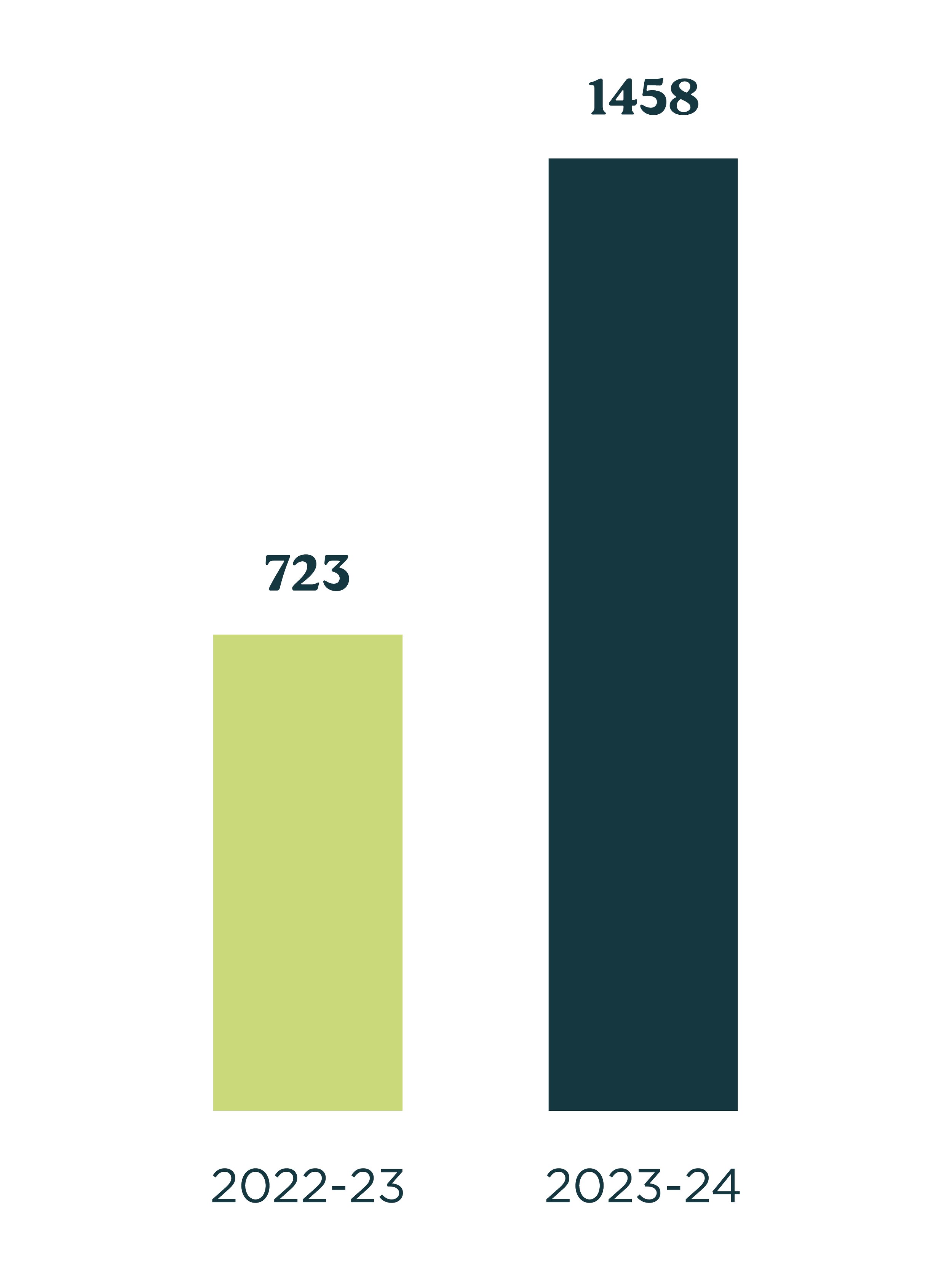
In planting season 2022-23 Raise engaged 723 people in the process of designing and creating woodlands for Cumbria Community Forest. This doubled to 1458 people in 2023-24 (figure 11) – a testament to the helping hands and hearts of Cumbrian communities, and the hard work of our growing team!
Figure 11: Number of people engaged in designing and creating woodland for Cumbria Community Forest
Through our site delivery in 2023-24, we enabled (figure 12) 110 training opportunities, of which:
- 33 were in woodland design;
- 59 in woodland establishment;
- and 18 in woodland maintenance.
… and 54 employment opportunities [S] for those already working ‘green jobs’, of which:
- 7 were in woodland design;
- 40 in woodland establishment;
- and 7 in woodland maintenance.
Figure 12: Training and Green Job opportunities through site delivery for Cumbria Community Forest (planting season 2023-24)

[M] Calculated by adding Trees outside Woodlands (ToW) area (2020) to the National Forest Inventory area (2020, 2021, 2022). ToW is not updated annually, so there may be a large increase in area which shouldn’t be attributed to a single year, when a new release becomes available in the future.
[N] Based on Forestry Commission’s (FC) National Forest Inventory data, covering woodland blocks greater than 0.5ha. Does not include Trees outside Woodlands.
[O] Based on FC’s definition of sustainable woodland management: “woodland managed to the UK Forestry Standard that has a Woodland Management plan, or for which FC has provided a grant or felling licence in the last 15 years. It also includes all woodland in the nation’s forests managed by Forestry England, and all woodland on the Defence Infrastructure Organisation training areas. It is recognised that other woodland might be considered as managed as well.” See page 11 of Forestry Commission Key Performance Indicators (2024)
[P] Using Forestry Commission’s definition of sustainable management: woodland managed to UK Forestry Standard with a Woodland Management plan or for which a felling license has been issued in past 15 years.
[Q] We’ve delivered 43 separate woodland establishment sites between 2021 to 2024, and 17 of these have met the ECF Access Standard.
[R] The ECF Access standard differs from the Woodland Trust Access Standard, which states that: no person should live more than 500m from at least one area of accessible woodland at least 2ha in size; and there should be a woodland of at least 20ha in size within 4km of people’s homes. Many of England’s Community Forests schemes are small scale – less than 2ha in size – yet are still highly valuable for communities especially where space for, and access to woodland is limited.
[S] ‘Employment opportunities’ means a work contract for businesses or individuals already working in the green sector to design, deliver or maintain a site.
Case Studies
Visit our page of Case Studies to learn more about individual woodland creation sites which have been delivered as part of Cumbria Community Forest.
[17] Office for National Statistics (2022) Population and household estimates, England and Wales: Census 2021. Available at: https://www.gov.uk/government/publications/census-2021-first-results-england-and-wales/population-and-household-estimates-england-and-wales-census-2021
[18] Ministry of Housing, Communities and Local Governments (2019) English Indices of Deprivation 2019 FAQs. Available at: https://assets.publishing.service.gov.uk/media/5dfb3d7ce5274a3432700cf3/IoD2019_FAQ_v4.pdf
[19] Woodland Trust (no date) Natural Regeneration. Available at: https://www.woodlandtrust.org.uk/plant-trees/natural-regeneration/#:~:text=Natural%20regeneration%20can%20create%20more%20natural%20landscapes%20and,soil%20nutrient%20uptake%2C%20and%20sharing%20resources%20between%20trees.